Showing posts with label hiking. Show all posts

Wednesday, September 8, 2010

Hike: Camel’s Hump Summit via the Monroe Trail, Vermont

“Well, this mountain kicked my ass.” Those are the words my little brother, Dan muttered as we finally neared the summit of Camel’s Hump Mountain. After nearly two hours of steep incline, a few rock scrambles and more tree roots than I can count we were finally getting close to the end of the 3.75 mile trail to the top of the mountain. It was, indeed, a tough climb to the top and it was a relief to know that the end was in sight…well, sort of.

At about 12:30 in the afternoon, my little brother, SCAMP (the dog), Mike and I started our hike up to the top of Camel’s Hump, the third largest mountain in Vermont, part of the Green Mountains and perhaps that state’s most distinctive peak. We were all looking forward to a nice hike to the top of the mountain. Although we should have known it would be tough, we were walking up a mountain after all, we really didn’t know what we were getting ourselves in to as we started out on a single track dirt trail.

We quickly fell in to three separate hiking patterns: Mike hiking ahead with SCAMP, Dan not far behind and me bringing up the rear. The trail went up, up, up relentlessly and we took a break for water and to catch our breath when the trail intersected with the Dean Trail.

Monroe Trail sign

At this point, we fell in to a new routine: Mike still hiking ahead with the dog, Dan ambling along the trail and me some where in the middle attempting to keep up with Mike and the dog without losing track of Dan. One of the things I love about hiking is that it satisfies my contradictory desire to be both alone and with our people. As we hiked we did very little talking, we weren’t even in sight of one another for a majority of the time, and yet, I loved that we shared this experience.

Most people would think that hiking up a mountain, being constantly out of breath and having to scramble up and over rocks sounds like a form of punishment or torture but I love it. Getting to the top of a long trail up a mountain is a uniquely satisfying feeling. It is filled with triumphs (yay, I made is to the top of this climb) and moments of renewed determination (but I have miles more to go). There are rewards – a sudden clearing of the trees at a beautiful vista of the mountains surrounding you – and moments of quiet reflection as you walk through a forest that has been around longer than you can imagine.

This hike did not disappoint in any of these regards. There were very few switchbacks up this mountain, just a relentless incline through the forest and over the rocks and roots. Most of the time we were under tree cover, which kept us relatively cool, but there were a few spots where we out in the sun. It was actually a pleasant day for hiking (I know most Vermonters would probably say it was hot since it was up in to the 80s but considered there was little humidity and that all I’ve had for the past few weeks is to sticky, gross upper-90s in DC, I thought the temperature was refreshing).

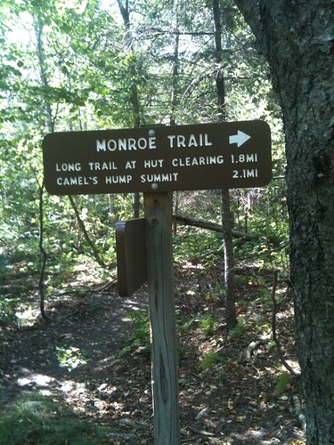
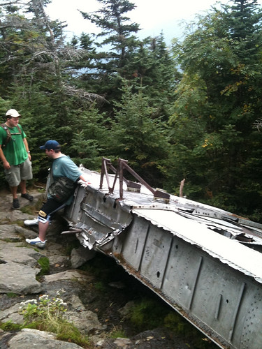
Nearing the top of the mountain and just over three miles, we started to keep our eyes out for the short side trail that would take us to the wing of a B-24J bomber. In 1944, during World War II, the bomber was out on a training run and crashed in to the mountain. The plane (and the several crew members who died) was eventually recovered with the exception of the wing which sits just off the Monroe Trail.

B-24 J wing 2

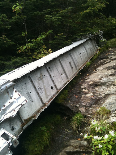
The wing has weathered the 60-plus years on the mountain well but it seems so out of place in this setting. It is definitely one of the most unusual things I’ve encountered out on a hike.

B-24 J wing

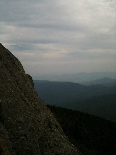
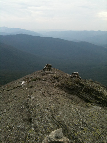
Not long after the seeing the wing, we finally reached the alpine zone and the summit. It was a relief to finally reach the top; we were tired of going up. I was surprised by two things at the top of the mountain: 1) at some point during the hike, the clouds had rolled in and it was overcast and 2) it was super windy. As a result, it felted like we had hiked out of one day and in to another.

Near the summit

Near the summit 2

Following a hike description we found online, we decided to hike the Long Trail down the mountain, hook up with the Dean Tail after about a mile and then get back on the Monroe Trail a bit under 2 miles from the trail head. As it turned out, this ended up being a bit of a misstep on our part. Since everyone was exhausted from the trip up we probably should have just stayed on the Monroe Trail, retrace our steps back to the start. However, we decided to brave the unknown.

This section of the Long Trail ended up being quite difficult. There was a great deal more rock scrambling and one point we even had to carry the dog over a section of rock. It was a tough hike down because of the steepness and the fact that we weren’t sure we were on the right trail at one point, plus it took us longer to climb down that we anticipated so there were some tense moments before we finally popped out on the Dean Trail and then saw the sign for the Monroe trail and the parking area.

Despite the exhausting climb down (oh man, my quads were toast from the climb up so they were nearly shot for all the downhill stuff), I think the Long Trail portion would have been an awesome climb up. It would have been steeper and tougher, with more hands and knees rock scrambling but it would have been fun to tackle those sections with fresher legs.

We finally made it back to the trail head, all four of us completely spent. It was a fun hike and I highly recommend it for anyone who’s in good hiking shape. I’d love to do it again.

Saturday, November 7, 2009

OLD RAG MOUNTAIN – HIKE

The summit of Old Rag Mountain, in the Blue Ridge Mountains and Shenandoah National Park, is at 3,291 feet and on a cool, crisp September morning we set out to conquer it.


The guide books and trail information provided by the park were quick to stress to extremely strenuous nature of this over 7 mile circuit hike and the one thing I worried about the day before and that morning as we drive to the trailhead was that it cautioned hikers to not attempt it if the rocks would be wet. Despite the rain of the day and night before, we (perhaps foolishly) stuck to our plan to hike Old Rag Mountain that morning as opposed to the next day (a Saturday, a weekend = even more crowds).


For some reason, we were reassured that our car wasn’t the first one in the parking lot at the trailhead. What this really meant was that there were 3 other groups of hikers foolish enough to hike despite the warnings; however, we chose to take it as a sign that it was OK to hike the trail. How bad could it really be, we asked ourselves, if other people are hiking it ahead of us. We are the best hikers out there (nor are we the worst and more importantly, nor does that mean the 3 groups ahead of us were any better than us), so if these other people could do it, so could we. Well, that is what we reasoned, anyway.


We got our Camelbaks ready and ourselves situated for a long hike and took off down the trail, determined to beat the park services’ time estimate of 7 hours for the circuit hike (5.5 for the out-and-back to the summit). As we headed off, I was a little bummed that the day was overcast and gray; the mountain seemed quiet.


The trail was quick to become steep and before we knew it we began a series of several switchbacks that would take us up the mountain for a bit under 2 miles when we would hit the strenuous rock scrambling that would take us to the summit (roughly a mile long). The switchbacks were steep but manageable. For some reason, and I really cannot explain this, I find it to be a very powerful experience to trudge up a mountain trail – heart pounding, blood pumping, leg deadening, lung exploding. It was amazing how we slowly emerged above the fog and realized it was a beautiful, sunny, lively day on the mountain above the fog line.


We took a single rest on the way up and it wasn’t long before we reached the first overlook.


As the trail descriptions promised, once we passed this first overlook the rock scrambling began. We squeezed our way between boulders, climbed up and over rocks, ducked through “caves” and scrambled our way along the trail. We even came to one place that we just couldn’t figure out how to proceed. Mike ended up having to boost me up from behind and once I was up, I had to pull him up. It was quite the team effort and I was so proud of Mike because I know he was fighting his fear of heights.


I had so much fun on this trail. It is the type of trail that keeps you actively engaged, both your mind and your body, as you have to think your way through it. Where do I put my hands? If I put my left foot in that crack, where will I put my right foot next?


However, the fun eventually ended as we reached the summit and were able to take a break. I am proud of our foolish journey to the top of Old Rag Mountain. We worked together and made it to the top together. It is a wonderful experience to share with someone.


After soaking in the views from the top…


…we headed back to the mountain, following a different trail that was longer but lacked the rock scramble. On the way down, the grade was much more gradual and after passing two day shelters along the trail, we came to a fire road that led back to the parking lot.


Two things struck me on the way down. One, it was neat to slowly walk back in to the fog. It felt like were reentering the world, as if, the sunny, bright day above the fog was somehow a dream world that we couldn’t remain in too long. Second, the trail on the way back was so drastically different from the rock scrambling and switchbacks on the way up it was hard to believe they both led to the same point.


Satisfied with our hiking for the day, which took us 4 hours and 15 minutes to complete (7 hours, ha!), we headed back to camp. I highly recommend this hike to anyone interested in a challenging and fun experience. We had a blast!


We met Mr. Turtle on the way up the mountain.

A view from the first overlook.

Along the trail, just before the rock scramble. It felt like we were floating in the clouds. It was amazing.


Mike taking a photo break along the trail.


I believe this is called Little Devil's Staircase. Very cool!


The view from the top of the mountain.


Descending back in to the fog.

Us at the top - we made it!


OVERALL RUN FALLS - HIKE

The hike toward Overall Run Falls starts at the Traces Trail in Matthews Arm Campground (where we were camping) so our drive to the trail was extremely short. In fact, we were hiking the trail within 5 minutes of leaving camp!


Unlike the constant and immediate up, up, up of the Old Rag hike, Overall Run Falls was flat for the first few miles and then went down, down, down. About an hour, maybe an hour and a half, in to the hike, we passed a trail marker that said Overall Run Falls was .4 miles away. We walked, saw a puny “waterfall” coming off the cliffs across a small valley from the trail, I took a picture and then kept going, looking for the “real” waterfall. Slowly down the mountain we went, both of us thinking that for all this down, hiking back up was going to be rough and this waterfall better be worth it. However, the trail just kept going. Each step down the mountain was a tough step up the mountain we’d have to make on the way back. About 30 minutes after passing the trail marker (and much further than .4 miles), we finally decided that that scrawny waterfall we had passed was probably THE waterfall and exhausted, we headed back up the mountain.


As we passed by the waterfall on our way up, out of breath and Mike struggling because of “cement legs” we couldn’t help but be disappointed – it must be better in the spring after the snow melts I told myself. Mike didn’t even stop to glance at it as he trudged past.


To make a slow story short, we eventually made it back to the car and Mike definitely perked up after we climbed back up the mountain and made it back to flat land over the last couple miles.


Hike – close to 7.5 miles, round trip (should have been 6.5 miles)


Camping in Shenandoah National Park - September 2009

Before our long weekend in September, Mike and I had some camping experience together but we’d only ever been camping on his parents’ property on the Eastern Shore of MD. In many ways, these prior experiences were more rugged (gathering firewood, not buying it; no restroom facilities; no car close by to keep supplies in, just the four-wheeler) and yet it still felt like we had not ever “really” camped because we always had the safety and comfort of the house to fall back on if we needed it (it was about 1.5 miles away).

We had decided to make our first “real” camping trip be at Matthews Arm Campground in Shenandoah National Park. I think both of us were a little nervous about the trip as we headed out Thursday afternoon but we faced it bravely and with a sense of humor.


We stopped in Front Royal, VA for supplies (a tarp because of the rain/wet ground, a cooler and food) before heading to the northern entrance to the park and Skyline Drive. The ranger at the gate took our park fee and suggested we head to the Elkwallow Waystation two miles north of the Matthews Arm Campground, in order to purchase our firewood before the store closed at 7. It was about 5:30 when we entered the park and she mentioned it should take about 40 minutes to drive to Elkwallow. As we pulled away from the gate she told us to drive careful because there was lots of fog on the mountains.


She wasn’t kidding! Much of the 20+ miles we drove on Skyline Drive that evening were dense with fog and when we finally climbed above it, it was an amazing sight to see.


The park ranger was right on the money with her suggestions, except the store at Elkwallow actually closed at 6 so we just missed it. Luckily, as we were poking around, an employee said she could sell us a bag of firewood and just ring it up in the morning. Thank goodness! We would have fire!


Around 6:30 that evening, we finally got to our campsite at Matthews Arm and started to set up. We laid down the new tarp (best purchase of the trip), pitched our tent and got the campsite ready. Once we were finishing setting up, we heading off on a short hike prior to starting a fire and making dinner.


The Traces Trail is a short, 1.7 miles hike encircling the Matthews Arm Campsite. It is named Traces Trail because there is evidence (stone fences and foundations) of settlements in the area. It was a nice hike with enough rocks and roots and slight ups and downs to keep things interesting. Along the way, we saw several deer and even spotted the “traces” implied by the trail name.


It was dark by the time we made it back to camp so we found the flashlights and lanterns and worked on starting a fire. Up until this point, the rain that seemed imminent had actually held off. There was some drizzle and mist on the drive out to Shenandoah but it had stopped by the time we got the park. However, as we were splitting up the firewood to make smaller starter pieces the rain started coming in fits and spurts. It was never a hard rain; however, it did put a damper on our fire, which we were never able to coax in to a decent-sized campfire. Still, in spite of the sporadic rainfall, we did manage to cook some hotdogs and enjoy an evening around the campfire.


It wasn’t long before we decided to call it a night, after straightening up camp and the supplies in the car, we snuggled in to our tent thankful for the dry and warm spot to sleep (it was in the low 50s that night). Just as we settled in for sleep, the rain started falling harder and more steadily. Lucky timing for the second time that day. Also, it turns out our cheap, $30 tent from Target was in fact waterproof so maybe we should consider that three-times lucky.


Friday morning we woke up early because we wanted to get to Old Rag Mountain early to ensure a parking spot near the trail. I think the rains from the previous day kept many potential hikers from getting a fresh start on the day because we didn’t encounter the crowds we expected on this popular hike.


The hike was a blast and we decided that this was definitely the best hike we’d been on outside of Maine (Acadia National Park still holds my heart when it comes to hiking). Here’s a description and more pictures of our hike.


We were exhausted after successfully tackling this tough hike and once we made it back to the car, we decided to grab a bite to eat in the small town nearby, Sperryville, VA. We found a wonderful place, serving freshly prepared (often local) food called Rae’s Restaurant. I had a Black Bean Burger and salad that was truly yummy.


We headed back to the campsite, with a short detour south along Skyline Drive to check out the Big Meadow area and stop at the souvenir store for a hat (for Mike) and some local honey (for me). Content after the long day, Mike started working on our fire for the evening and I relaxed off to the side intermittently watching his progress, offering advice and bellowing services, but mostly reading and relaxing. Once it got dark, we munched on grilled cheese sandwiches cooked over the fire and made s’mores but even the scrumptious camping food couldn’t keep the sleepiness at bay and before too long we gave in and called it an early night.


Saturday morning, we were up even earlier in order to pack up the campsite and load the car. Even though we were still planning on hiking in the park that morning, we wanted to check out before we set off on our final day of adventure. As we packed up, one of the things that became apparent was we were both sore from the strenuous hike up Old Rag the day before, Mike more so than me. We decided to take the trail to see the highest waterfall on the mountain – Overall Run Falls at 93 feet high – rather than the trail to Little Devils Staircase (another rock scramble) as we had planned.


We ended up hiking much further than we intended that morning and the trail ended up being much more strenuous than we thought. The Overall Run Falls was actually a bit of a disappointment but I would like to try this hike again in the spring. I think that is when the falls might be more impressive. In addition to this disappointment, we were both more worn out by Old Rag Mountain than we had thought and I don’t think we gave this trail a fair shot. We were excited to get back to the car and home.


As we drove north along Skyline Drive, our camping adventure coming to end, Mike declared that after all that hiking and camping, he had a hunger than only a steak could conquer and so, we headed home in search of steak with a successful camping experience coming to end.


Tuesday, September 8, 2009

Billy Goat Trail A – Hike

Billy Goat Trail A, along the C&O Towpath , is one of the best hikes in the Metro DC area and definitely my favorite. At only 1.75 miles long (not including the walk from the parking lot and along the towpath, all in all a 3.5 mile round trip), the Billy Goat is a great hike for early on weekend mornings before lunch. It doesn’t take the whole day to complete but it is huge on fun.

The trail is a rock scramble for well over 75% of its length and includes some great opportunities to jump from rock to rock, climb up and down the rock face, and experience great views of the Potomac.


Early Saturday morning (we got to the towpath parking lot by 9), we (Mike and I) headed out to conquer the trail. We’ve done this trail a dozen times and it has yet to get boring and this time Mike threw in an extra twist. He decided to try to hike in his new Vibram FiveFinger KSOs.


He definitely got quite a few questions from other hikers for his odd choice in hiking footwear. The choice was a success in that nothing was broken – no turned ankles, no toes caught in between rocks, no bottom of foot pain. However, the rocks were still covered in a dirt and sand from the trail washout a few months ago and that made for some slippery going without the traction.

We completed the hike and decided to take the trail above the towpath back to the car in order to stay in the shade. We managed to beat the heat of the day and had a wonderful little hike to start our day off on the right foot. I highly recommend this trail to anyone with a moderate level of fitness. It is not to be missed!

**Sorry for the tiny pictures...I forgot my camera and all I had was my phone!***

Wednesday, March 11, 2009

Hike - Difficult Run to Great Falls Loop

Just over a week ago, it snowed.

This past weekend it was in the upper 60s/low 70s.


We would have been silly to not take advantage in the break in the cold temperature and get out for a hike.


Something we hadn’t done in a few weeks.


We had driven out to Great Falls before; paid the park fee and mingled with the relatively large crowds at the Falls and surrounding trails. However, this time we decided to experience the area in a slightly different way.


We drove out toward Great Falls, VA and parked in a lot on the side of the road near Difficult Run. I was concerned that the trails would be thick with mud after the previous week’s snow melt but as we took an unmarked trail across from the lot in to the woods, I noticed the ground was soft and squishy in some places but absolutely passable.


After a few minutes on the unmarked trail we reached a large path through the woods and headed off toward the Falls. It was approximately a mile to the Falls and as we hiked in, we noticed the long line of cars above us waiting to get in to the park. We realized how much more we preferred reaching the park our way – no waiting in line and no park fee!


Before we were able to reach the park, we hiked along a stream and began hearing the strangest noise. After first, we thought it was a flock of birds that we’d never heard before but then we realized it was coming from the water. It turns out the noise was being made by frog, not birds! It was the strangest thing and had us stopped in our tracks for several minutes.


Not long after listening to the frogs we began to hear the happy shouts of little kids playing outside. We were getting closer to Great Falls. Since we had been to the park before, we didn’t spend much time at the Great Falls overlook but we did stop long enough to take a picture and check out all the other people taking advantage of the nicer temperature by having a picnic.


View of Great Falls from the park overlook.


Next, we headed downriver along the River Trail. There were quite a few people on the trail and at the numerous overlooks along the trail but the crowd

eventually thinned out. Along the way, we trampled over several wooden bridges crossing streams and small falls feeding in to the Potomac River and even saw some ruins of the old lock system.

View of the Billy Goat Trail from the other side of the River.


By the time we reached the trail intersection that would take us back along Difficult Run, the crowd had more or less disappeared but we still occasionally passed other hikers. The climb out of the River Trail was uphill and was a nice change of pace. We hiked up it, breathless but happy when we reached the top and began descending toward Difficult Run.


View of Mather Gorge along the River Trail, Great Falls, VA.


We took a slight detour to see where Difficult Run meets the Potomac River before backtracking and headed back toward the car.


At the end of the 3.5 mile hike, I was glad it was over since my legs were tired from my run that morning but it felt good to get out and hike. It always makes me feel like I actually accomplished something on the weekends we hike.


Us!

Tuesday, January 6, 2009

Hike: Prince William Forest Park, Attempt #2 – Success!

Before noon on Saturday, we set out to hike the trails of Prince William Forest Park in Prince William County, VA. We could not have asked for a more perfect hiking day. The temperature was in the low 40s; however, as we hiked along with the bright sun, clear sky and lack of any significant wind, it felt more like an early spring day. We even had to stop and shed some layers.

Mike had mapped out a wide loop around the southeast section of the park. With 37 miles of hiking trails in the, we set out to hike approximately 7 to 8 miles of them.

After checking out the Visitor Center and paying the $5 park fee (good for one week), we started the Garmins and head out on the west branch of the Laurel Trail Loop. This trail is a short little loop off of the picnic area next to the Visitor Center. A little less than half way around the loop, we came to a wooden suspension bridge that connected to the South Valley Trail, which we took heading north and west, following the South Fork Quantico Creek.

The trails through out the park are mostly dirt and occasional rocks and roots. This time of year it was covered in long-dead leaves, which made for some fun trails as we were able to crunch and kick through the small piles. There was also the occasional uphill and/or downhill but the hike was mostly flat.

The South Valley Trail can be followed all the way to the other end of the park; however, we jumped off relatively soon on to the Turkey Run Ridge Trail which slices up the middle of the park toward one of the larger campgrounds, Turkey Run Ridge Group Campground. From the campground we took the Mary Bird Branch trail toward the Quantico Falls Trails.

After only a few minutes on both these trails, we came to Quantico Creek and the Cascades. This is where the Fall Line is located, or where the Creek is no longer navigable by boat. The water throughout the park was low; however, it was easy to see how high the water could get and despite the low water, the cascades were interesting to see and hear (there was a constant burbling on the trails as you descend to the creek). Also, there was some evidence of beaver activity near the cascades…although, we couldn’t help but wonder if the beaver evidence wasn’t possibly man-made.

After taking a short break at the cascades, we headed south along the North Valley Trail, briefly cutting across Quantico Creek to the very edge of Prince William Forest Park. Here the forest, through which the trail cuts became a bit thicker for a while and we came across the ruins of the Cabin Branch Pyrite Mine. Abandoned nearly a century ago only a few foundations are left of the mine and the mine shaft had been covered over. We couldn’t help but be amazed at how quickly nature takes back its domain once people stop maintaining it.

Before long we were back on the other side of the Quantico Creek and quickly heading toward the end of our hike. We came up the remains of a suspension bridge similar to the one seen before as we began out hike crossing over to the South Valley Trail. One side of the bridge was still standing, the rusted cable and large bolts were scattered around and metal still stuck in cement was along the banks of the creek. We following the North Valley Trail until we came to the suspension bridge that we had crossed at the beginning of our hike back to the Laurel Trail Loop.
Back on the Laurel Trail Loops we decided to follow the east branch of the trail to get back to the car and knowing we were close to finishing our hike, I quickened the pace. I could feel my legs beginning to tire; I was really feeling the morning’s run after hiking more than 7 miles and I was eager to be done. As we crested a small hill, a giant green water tower seemed sprang up. I had hardly noticed it behind the Visitor Center as we were heading out and now here it was looming large, signaling the end of our hike. “How could I have missed that,” I wondered.

And then the hike was over, 7.5 miles, 2 hours and 50 minutes after we had started, we looped through the southern portion of the park and we were back at the car. Prince William Forest Park is a great place for a long, winding hike in the woods. Although the trails are not wide and have the occasional obstacle, they are well marked and provide just enough to keep me on my toes. With so many trails that interconnect, it would be possible to go again and again without taking the same route twice. I look forward to going back in order to check out the north section of the park which is supposed to have a more backcountry feel.

Saturday, December 6, 2008

Hike: Raven Rocks Trail

I stumbled on to a great website this past week - HikingUpward - and found a hike called Raven Rocks that looked like fun. We debated whether the elevation changes (3 steep ascents and descents along the way) would be too strenuous. I'm so glad we decided to face the challenge because this hike was worth it.

We drive a bit over an hour west of DC to get to the trail head in the Blue Ridge Mountains. As we started along the trail, which is really just a section of the Appalachian Trail, and followed the white blazes, I realized that this was actually the first time I've hiked on the AT! I've been sporadically and slightly obsessed with the AT since I read a book by a thru-hiker last year. I don't know if I would ever have the courage to put my life on hold and attempt a thru-hike but I think about doing it and I enjoy reading about people who have done it.

Anyway, I was excited to be on the AT as we made our way along the trail. It was a cold, cloudy day but I quickly warmed up as we hit the first of three ascents. At the top was a nice little overlook that gave us an excuse to stop and catch our breath. The trail was a fun hike because their were plenty of big rocks to navigate, rolling terrain and switchbacks. It was an active hike, which I enjoy.

After catching our breath, we continued on the trail, shortly hitting the steepest ascent. I enjoy hills in hiking and in running. The inclines and declines use different muscles than flat terrain and even when the leg muscles are burning and the lunges are working in overdrive, it feels good to get the blood pumping and I love that feeling of accomplishment once I've reached the top. Not one to shy away from an incline, this trail would test that enjoyment several times but I have a motto - "Steady Forward Motion." Just keep moving until you reach the top otherwise you'll still have more uphill to tackle once you've rested.

Breathless and bounding from rock to rock, we made it to Raven Rocks, a 2.7 mile hike, in approximately one hour ten minutes. Looking out over the Shenandoah Valley toward the Blue Ridge Mountains in the distance, even on an overcast day, made for an impressive sight. Despite the view, we didn't linger for very long at the top because a cold wind was blowing. We quickly headed back down the AT the way we came.
Near the top, the trail dips into West Virginia and had a sign to mark the border. After leaving Raven Rocks to head back, we noticed the other side of the sign -- Welcome to Virginia...Tennessee Border 535 miles!!!!


One of the things I enjoy about hiking, especially with Mike, are the topics of conversation and the return trip would not disappoint. We tried to figure out why some of the trees were charred (lightening, maybe?), whether trees make a sound when they fall in the woods and we aren't around to hear them and whether or not that proved I was a schizophrenic (I hope not).

With this conversation, our return trip seemed to fly and we made it back to the car in just over an hour. The trail to Raven Rocks and back was a strenuous but fun trail and it gets 5 stars in my book. It'll be fun to go back during the spring and summer to see how different it is with the streams running and the sun shining through the leaves.


Today's Daily Dozen:
Run - 3.96 miles, 4 min. run/1 min. walk x 7 intervals
5.5 miles hike - strenuous

Sunday, November 23, 2008

Hike: Catoctin Mountain Trails

In the past, I've always wimped out and hung up my hiking shoes when winter arrived and let the trails hibernate until spring (and warmer/nicer weather). I've been missing out for some years now! A trail is a whole new experience when it is blanketed in snow!

Yesterday, we decided to head up to Thurmont, MD to check out the trails on Catoctin Mountain. Mike went to school nearby at Mount St. Mary's University and he wanted to go back to the area to check out the hiking. We had decided to hike the 8.5 loop that hits all of the highlights within in the national park.

As we got closer and closer to Thurmont we noticed there was snow on the ground and cars. We were supposed to get some snow flurries on Friday and I believe it did flurry for a little while in the afternoon but down in DC it didn't amount to anything. Evidently, this was not the case further north!

We parked at the Catoctin Mountain Visitors Center and grabbed a map from inside. The Visitors Center was a surprisingly nice building, with some exhibits, restrooms, maps and a wonderful fireplace complete with roaring fire. After talking to the park ranger, we decided to hike the loop counter-clockwise and hit the more strenuous uphills first. I started the GPS and we headed off for the trails just after noon.

The first section of the loop is on Cunningham Falls Nature Trail (1.2 miles). We were quickly emersed in the forest, crunching snow and dead leaves under our feet, following the footprints of earlier hikers. Without blazes or other trail postings, these footprints were the our only guide along the trail. One of the things that struck me as we first started our hike was how different the mountain trails were compared to the trails along the Potomac River we hiked last weekend. The Billy Goat Trails were marked by the bright yellows and greens of leaves still clinging to the trees, and autumn. As we hiked Catoctin Mountain very few leaves were still hanging on to the branches and the few that were, were brown and appeared frail and brittle, as if they were using all their strength to avoid falling to the bright white snow below. The differences were visually striking.

The Cunningham Falls Nature Trail took us over MD 77 into Cunningham Falls Park (.4 miles) and lead us to Maryland's largest cascading waterfall. Honestly, the falls seemed a little underwhelming - really, that is the state's largest cascading waterfall, OK. Perhaps it is more impressive at another time aIt was a nice little waterfall and was obviously the main attraction in this area. We saw several hiking groups and families headed to the waterfall.

Afterwards, we backtracked to the state park and headed up Hog Rock Nature Trail toward Hog Rock Vista (1 mile). This section of the trail was much steeper than the previous trail but it fun. I love hiking hills and this section of the trail proved to be a surprising challenge. It was a deceptively long ascent and got mylegs, lungs and heart pumping. The crunch of the snow as we huffed and puffed our way to the level trail at the top was a wonderfully physical experience. And the views at the top, were worth the effort.

After stopping for a few minutes to survey rtThurmont off in the distance (and to catch our breath), we continued on Hog Rock Nature Trail toward Blue Ridge Summit Nature Trail crossing the Hog Rock Parking area (.7 miles). This section of the trail was more rolling than the previous two trails with short ups and downs. We quickly made it to Blue Ridge Summit Vista and has similar views on the other side of the mountain; however, we didn't linger at this spot.

Being unprepared for the amount of snow on the trails, our shoes were starting to get a little wet and we made the decision to cut our hike short and head back toward the Visitors Center, just over a mile and a half away. The trail was flatter for approximately a half mile and Mike took off on a run. Naturely, I had to give chase. This was my first time, however brief it happened to be, running on snow-covered trails and it was marvelous. The thrilling crunch of the snow underfoot combined with the heightened awareness of the terrain (rocks and leaves and roots), as I leapt over rocks and avoided slippery patches was a good deal of fun. I couldn't help but smile as I ran down the trail. It didn't last long but it was a highlight of the hike for me.

As we got closer to the end of the trail, the downhill section began and it was more or less downhill for the rest of the hike. Although my shoes were wet and my toes were just starting to feel the cold, I was a little sad to see the hike come to an end. We ended up hiking just under 6 miles (5 of actual trail and about another mile of backtracking and meandering) in roughly 2.5 hours. I can't wait to go back to the mountain and see what the other trails have in store for us.

We finished off our Saturday adventure with a quick swing through the Mount St. Mary's campus and then headed north toward Gettysburg for some lunch. I mentioned to Mike, "I love that you love to hike" and I do because these experiences are so much more rewarding when they are shared. I am looking forward to our next hike. Today? Maybe. Next weekend? Definitely!

Tuesday, November 18, 2008

Billy Goat Lite

Having slept in on Saturday for an oddly long time (10 hours, wow!) and then spending the entire day traveling to and from a wedding (Congrats to the Bride and Groom), I wasn't able to get in any sort of exercise and was resolved to making up for it on Sunday.

The day was forecast as a cold, mostly cloudy and windy day but there were promises of occassional breakthroughs of sunshine. Since my foot cannot handle the Billy Goat Trail we normally hike, I decided to check out the other two trails that make up the Billy Goat Trail system off the C&O Canal Towpath in Virginia. We loaded up the camel-baks and headed off around 10 in the morning.

The Billy Goat Trail A, the trail we normally hike, is 1.7 miles of rock scrambling with a few flat packed-dirt sections thrown in to give you a break. For this area, it is a very strenuous trail and is a great deal of fun. However, it is only one of three, there are also Billy Goat Trail B and Billy Goat Trail C, trails that make up the Billy Goat Trail "system." The B and C trails are described as the opposite of A - mostly dirt-packed trails with occasional rocks and one or two spots to scramble - and I wanted to see what they were all about.

As we headed off down the towpath towards B, the wind was whipping and I pulled my jacket out of my backpack; it was going to be colder than I thought. We turned onto B and were immediately surrounded by the woods between the Potomac River and the Towpath. The path was completely covered in the bright leaves that had recently fallen from the trees and the crunchy dead ones that had fallen a while ago. There is something nastalgic about stomping and kicking my way down a forest path littered with leaves and with the smell of nature (like dirt, only good).

A strong wind would frequently kick up reminding me that winter was no longer just approaching; it was about to kick down fall's door but it felt good to be out there as fall, and those final bright yellow leaves, hung on for just a little longer. I was between the seasons, when nature just keeps us guessing.

Both trails take you down to the Potomac River and then follow along the river for over a mile before turning back toward the towpath. Along the scrambling was held to a minimum, the occasional spots were fun. However, the reasons for experiencing these two trails are for the views of the Potomac.

The rock islands dotting the river and the spots of rough water along this stretch of the river always surprise me because I normally see the Potomac as it seems to meander past DC; it almost lingers. Billy Goat Trails B and C provide the views of the river's other personality and don't distract me with strenuous hiking. These two trails provide an opportunity to enjoy being out there for the sake of being out there - enjoying the sights, sounds, smells and feel of being out in nature hiking.
The sun poked out from behind the clouds a few times, just enough to provide some warmth, and once we were moving the cold didn't seem as biting or intimidating. The few scrambles provided some heartrate-raising opportunities and ensured we wouldn't be bored. We met a handful of people along the trails we weren't discouraged by the weather or the temperature.

As we finished Billy Goat C, we took the towpath back to the car almost 2 miles. All in all we walked/hiked 5.9 miles in 2 hours 10 minutes. By the time we got back to the car, I was starving and I couldn't help but feel like I had earned lunch. It may not have been the most strenuous or the longest hike I've undertaken but it was incredibly satisfying.

Related Posts with Thumbnails